 |
Bungala Ridge Permaculture Gardens REDUCE ... REUSE ... RECYCLE ... REPAIR ... RETURN ... REVEGETATE ... REPLENISH |
||||||||||
|
|||||||||||
|
|
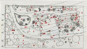
Site Map and Element Key The permaculture design site plan below covered the area immediately around the house, and represents what we planned to do way back in 1997. Much has changed! As the illustration shows we included a great deal of detail, and labelled each section with a element key for ease of identification. We found this approach very useful for organising our thoughts and creating the design. Our property extends another 60 or so metres to the south of the house, and east for about 120 metres. The hill slopes steeply away from the driveway by about 20 metres, which presented a challenge. We still need to create level pathways along contours to access most of our fruit trees. There is much work to be done in the orchard, most of which lies south of the plan shown. To the east lies zone 5 - the wild area. It was hard to establish indigenous plant species in this area, due to the dominance of olive trees which proved difficult to kill. We are gradally knocking them back, but can't get machinery up the sandy slope to uproot them. Zone 5 leads to the woodlot, which we're renamed the 'forest' as we doubt we'll ever chop the trees down. The branches that drop around the property, in addition to waste pallets from local businesses, supply us with sufficient firewood for our stove.
|
Hot Links!
This site is sponsored by EditRegion2 |
|||||||||
|
|
|
|
|||||||||